
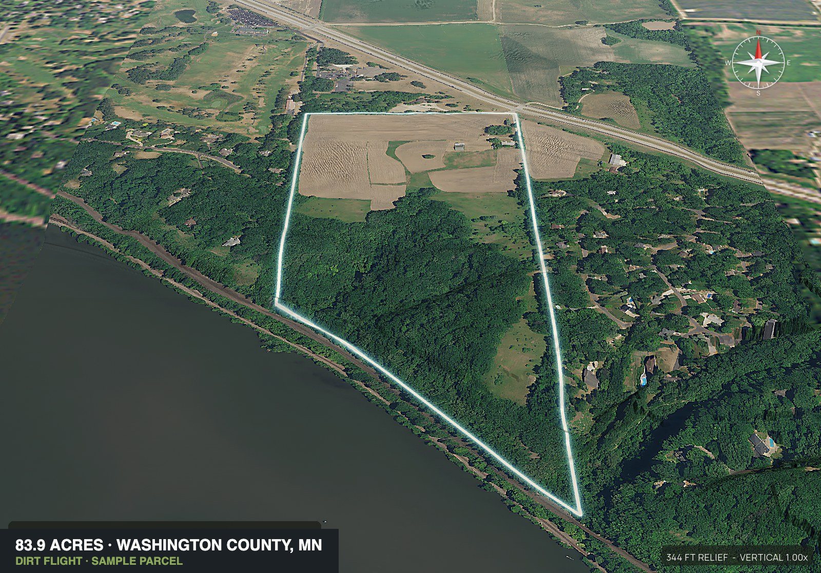
Aerial photos of any land listing, boundary drawn, about ten minutes after you enter the APN.
Get a parcel under contract in the morning and have it listed before lunch. Put in the APN. DirtFlight draws the boundary, then renders the top down aerial, the four cardinal 3D views and an 18 second orbit around the tract. Dirt is $29 a parcel and Paydirt $79, or $199 a month for PayDirt Pro (20 packs). Paydirt adds the contour map, the infrared view and a social kit that is ready to post, with captions for each platform, plus pop-out photos. Nothing waits on a pilot, a quote, or the weather.
Everything under the boundary.
A listing shows you the picture. Due diligence is everything behind it. Scroll and we will take this parcel apart.
Enter the APN. Get the whole stack.
About ten minutes from the parcel number. Nothing flown, no pilot to book, no site visit.
Sample parcel, Carver County, Minnesota. Layers are for marketing and screening, not a survey.
A parcel goes under contract on Monday. Most listings sit dark until the next Monday.
Two or three days for a quote. Two or three more before anyone drives out. Another few for the edit to land in your inbox. Meanwhile the listing is live with one grainy screenshot on it, and the buyers who scroll past do not come back.
DirtFlight is an aerial imagery service for United States land parcels. You enter a parcel number and it renders the whole tract in about ten minutes: a boundary outlined top down aerial, four cardinal 3D views, an 18 second orbit video, a shareable listing page and a parcel info sheet, with full resolution files of every view in the pack. Dirt is $29 a parcel and Paydirt $79, or $199 a month for PayDirt Pro (20 packs). Paydirt adds the road frontage hero, a contour map, context and access maps, a land health infrared view, a ready to post social kit, pop-out photos from nine directions, an interactive 3D explorer and measured diligence layers covering buildability, soils and septic, streams and ponds, power lines and utilities. PayDirt Pro adds your logo, embeds on your own site and LiDAR canopy and bare-earth views. Nothing is flown, so there is no pilot to book, no travel charge and no weather window. Boundaries are approximate and are not a survey. Buildable: ground outside mapped slope, flood and wetland areas. A screen, not a zoning, septic or permit approval.
How it works: three steps, and none of them involve a calendar.
We do not hire drone pilots. Every view is rendered.
We pull the parcel
State, county, APN. Or the address if that is all you have. Adjoining parcels can be entered together and merged into one boundary, so a two APN tract reads as one piece of ground.
We render every view
The engine takes the best available imagery for that ground, drapes it over the elevation model, traces the boundary, and works through the shot list. Dirt gets the top down, four obliques and the orbit. Paydirt adds topo, context, access and land health.
You download and post
One zip with full resolution files of every view in your pack and MLS sized files. A shareable listing page comes with it; on PayDirt Pro and up it also gets an embed code for your own site. The social kit and the pop-out photos are Paydirt items.
What you get: every view below came out of one APN entry.
83.9 acres in Minnesota. Two adjoining parcels, merged into one boundary. Rendered as a Paydirt pack.
The kit also carries captions written for Instagram, a Facebook page, Facebook land groups, Facebook Marketplace, TikTok and Shorts, a posting plan with alt text and hashtags, and a QR code to your share page. Every download holds one full resolution folder, the boundary as KML and GeoJSON, and a facts file.
- Acreage83.9 acres
- StateMinnesota
- Elevation on the parcel689 to 891 ft
- Relief203 ft on the parcel
- Parcels2 APNs, merged
Imagine waking up on rolling hills with room to look around. This 83.9-acre parcel rises and falls across the land.
83.9 acres in Minnesota
203 ft of elevation change across the parcel
450 ft of road frontage
#landforsale #minnesotaland #acreage
Every frame goes out under your name.
On PayDirt Pro, PayDirt Pro+ and Enterprise, send us your logo once and it is placed on the imagery, on the social kit, the carousel and on the shareable listing page you text to a buyer. There is no DirtFlight watermark on a branded pack, no badge in the corner and no credit line. The seller sees your brokerage, the buyer sees your brand, and nobody has to know how the pack got made.
Built by a land investor who got tired of waiting on photos.
-
01
Land investors
Carry costsUnder contract at noon, marketed by dinner. Every day a parcel sits unlisted is carry you do not get back.
-
02
Agents and brokers
Listing appointmentsWalk into the listing appointment with the aerials already rendered. It closes listings, and it costs you one APN lookup.
-
03
Rural and ag teams
Boundaries and waterField boundaries, tillable versus timber, and where the water sits, in one look, on every tract you take on.
-
04
Timber, hunting and rec
Relief and coverRelief, cover and access are the whole pitch on recreational ground. The topo and the orbit show all three.
-
05Start free
Owners who just want to see their place
No listing requiredNo listing, no agent, no reason beyond wanting a good look at your own ground. Plenty of people order a pack for exactly that, and the orbit video hanging on a screen at the farmhouse is worth the ten minutes.
Does DirtFlight replace hiring a drone pilot? No, and it is not trying to.
A drone gets you real photographs of what is on the ground today, at any angle you want, and nothing renders that. DirtFlight does the other half of the job: the parcel up fast, the boundary drawn on it, and the ground facts a buyer asks about before they drive out.
| DirtFlight | Hiring a drone pilot | |
|---|---|---|
| What it costs | $29 or $79 a parcel, flat, or $199 a month for PayDirt Pro (20 packs) | Commonly $150 to $600 for a rural shoot, plus travel that grows with the drive |
| How long it takes | About ten minutes | Typically five to nine days, weather permitting |
| Boundary drawn on every view | Yes | No, a pilot cannot see the property line |
| Slope, flood, wetland and soils measured in acres | Yes, on Paydirt | No |
| A photograph of the ground as it is today | No, it is rendered from recent aerial imagery | Yes, and this is the real advantage of a drone |
| Airspace approval or an FAA waiver | None, nothing flies | Required, and it can stop the shoot |
| Works on a parcel you have not closed on | Yes, no site access needed | Needs permission to be over the property |
Plenty of listings run both. Put the parcel up the day it goes under contract with DirtFlight, and book the pilot for the hero shot if the property earns one.
Sell it whole, or sell it in pieces.
Land that sits side by side rarely sells one way. One buyer wants the whole property, another only wants the piece along the road, and a third will take the back acreage at the right price. List the whole tract and every lot, each with its own listing page, and each buyer finds the page built for the way they want to buy.
Enter the parcel numbers of your adjoining parcels once and they render as one tract. Tick the whole tract, each parcel as its own lot, or both, and every choice you tick comes back as its own listing-ready pack. A single tract can also be split into lots, drawn on the map or uploaded as a plat, once the tract has rendered.
Get startedBoundaries are approximate and are not a survey. Whether a tract can be split into lots is up to your county.
Three adjoining parcels come to about 80 acres. One buyer may want all of it, while two others may only want the 20 acre piece or the 40. Enter the parcel numbers once, tick the whole tract and each parcel as a lot, and you get a listing-ready pack for every way you might sell it, so you can list the whole tract and the lots the same day.
- The whole tractFor the buyer who wants all of it80 acres
- Lot 1For the buyer who wants a small piece20 acres
- Lot 2For the buyer who wants the larger piece40 acres
- Lot 3For the buyer who wants the other small piece20 acres
One entry of the parcel numbers gives you all four, and the Subdivide / Multi-parcel pack price below covers them.
Dirt gets the listing up.
Paydirt gets it shared.
Same parcel, same ten minutes. Pay per parcel, or subscribe to PayDirt Pro or Pro+ if you run several parcels a month.
Free for a limited time. Prices apply after launch.
Prices are in US dollars. No travel charge, no minimum order and no retainer. Dirt and Paydirt are flat per parcel; PayDirt Pro and Pro+ are monthly, with a hard cap on packs each month: a Dirt pack counts as one pack, on a Subdivide / Multi-parcel pack the whole tract and each lot each count as one, regenerating a saved pack within 30 days does not, and unused packs do not roll over. Packs stay downloadable for 30 days; rebuild anytime from your saved parcel ($9.95 Dirt, $19.95 Paydirt). Paydirt keeps the diligence layers, the social kit and the pop-out photos to itself, so Dirt never includes them. Features marked coming soon are still being built and are not part of the product today. Boundaries are approximate and are not a survey. Pricing questions
One link you can text to a buyer.
Every pack comes with a hosted page holding the full gallery, the orbit video and the parcel facts. Send the link. On PayDirt Pro and up, drop the embed code into your own site.
Questions about aerial photos of land, asked before the first parcel.
What is DirtFlight?
DirtFlight is an aerial imagery service for US land parcels. You enter a parcel number and it renders the tract in about ten minutes. Dirt, $29 a parcel, is a boundary outlined top down aerial, four cardinal 3D views, an 18 second orbit video, a hosted listing page and a parcel info sheet, with full resolution files of every view in the pack. Paydirt, $79 a parcel, adds the road frontage hero, the contour map, context and access maps, the infrared land health view, the full social kit with platform captions, a posting plan and silent reels, pop-out photos from nine directions, the interactive 3D explorer and the measured diligence layers for slope, flood, wetland, soils and septic, streams and ponds, power lines and utilities. PayDirt Pro, $199 a month for 20 Paydirt packs, adds your logo, embeds on your own site and LiDAR canopy and bare-earth views. PayDirt Pro+ is $299 a month for 45 packs, and Enterprise is custom for teams and higher volume. Nothing is flown, so there is no pilot to book, no travel charge and no weather window. Boundaries are approximate and are not a survey. It is built for land agents, land investors and landowners marketing vacant ground.
What do you get in a DirtFlight pack?
Every pack carries a boundary outlined top down aerial, four cardinal 3D views looking north, east, south and west, an 18 second orbit video around the tract, a hosted listing page you can text to a buyer, and a parcel info sheet with acreage, location and elevation, plus full resolution files of every view in that pack. Paydirt adds a road frontage hero shot, a contour map with elevation stats, a context and access map, a land health infrared view, a full social kit with platform captions, a posting plan and silent reels, pop-out photos from nine directions, and an interactive 3D explorer carrying buildability, soils and septic, streams and ponds, power lines and utilities. PayDirt Pro adds your logo, embeds and LiDAR canopy and bare-earth views. Buildable: ground outside mapped slope, flood and wetland areas. A screen, not a zoning, septic or permit approval.
Do you send a drone pilot out to my property?
No. We do not hire drone pilots. Every view is rendered, which is why nothing waits on a quote, a flight window or the weather.
How long does it actually take?
About ten minutes from the moment you enter the APN. Get a parcel under contract in the morning and you can have it listed and posted before lunch.
Do I need the owner's permission or an FAA waiver?
Nothing flies, so no. The views are rendered, not flown. No overflight, no airspace approval, no permission to chase before you can market the parcel.
What does it cost?
Pay per parcel or by the month. Dirt is $29 a parcel and covers what you need to list: the boundary outlined top down, four cardinal 3D views, the 18 second orbit video, a shareable listing page and a parcel info sheet, with full resolution files of every view in the pack. Paydirt is $79 a parcel and adds the road frontage hero, the contour map, context and access maps, the infrared land health view, the full social kit with platform captions, a posting plan and silent reels, pop-out photos from nine directions, the interactive 3D explorer and the measured diligence layers for slope, flood, wetland, soils and septic, streams and ponds, power lines and utilities. Subdivide / Multi-parcel pack: $149 for the whole tract plus up to 5 lots. 6 or more: contact us for a quote. PayDirt Pro is $199 a month for 20 Paydirt packs, and adds your logo, embeds on your own site and LiDAR canopy and bare-earth views where LiDAR exists. PayDirt Pro+ is $299 a month for 45 packs and includes everything in Pro. Enterprise is custom, for teams and seats, Site Physicals, the full Site Diligence Report and higher volume; contact us. No travel charge, no minimum order and no retainer, because nobody drives out to the property. Packs stay downloadable for 30 days; rebuild anytime from your saved parcel ($9.95 Dirt, $19.95 Paydirt).
What does PayDirt Pro include, and what counts as a pack?
PayDirt Pro is $199 a month and includes 20 Paydirt packs each month, a hard cap, with your logo, embeds and LiDAR views on every pack. A pack is one parcel. On a Subdivide / Multi-parcel pack, the whole tract and each lot each count as one of the month's packs. A Dirt pack counts as one pack too. Regenerating a pack you already made, within 30 days, does not count. PayDirt Pro+ is $299 a month for 45 packs and includes everything in Pro.
Can I cancel PayDirt Pro any time?
Yes. There is no contract and no cancellation fee. Cancel whenever you like and the plan runs to the end of the month you have paid for, then stops. Anything you ordered per parcel is never tied to a plan.
What happens when I reach my monthly pack limit?
The cap is hard. After 20 packs on PayDirt Pro, or 45 on PayDirt Pro+, new packs wait until your next billing month starts, and your account page shows how many you have used. You can move up to PayDirt Pro+, buy a single pack at $29 or $79, or contact us about Enterprise for higher volume.
Do unused packs roll over to the next month?
No. Your monthly packs start over when your next billing month begins, and unused packs do not carry over.
How long are packs kept, and can I rebuild one?
Packs stay downloadable for 30 days; rebuild anytime from your saved parcel ($9.95 Dirt, $19.95 Paydirt). A pack that comes back broken is rebuilt free, and regenerating a saved pack within 30 days does not use one of your monthly packs.
How accurate is the boundary line?
Boundaries are approximate and they are not a survey. Acreage, boundary lines and road frontage figures are for marketing and illustration, so keep them out of legal descriptions, construction and property line disputes.
Where does it work?
Every county in the country. Type the parcel number, or draw the boundary on the map, or upload a KML, KMZ, GeoJSON or zipped shapefile, and the pack comes back the same. If a parcel will not come up from its number, you hear that straight away, before anything gets charged.
How current is the imagery?
One to three years old for most parcels. Every render uses the most recent coverage available for that county, and the date is on the pack.
Can I use these on the MLS and listing sites?
Yes. Every zip has full resolution files of every view in that pack and a set sized for the MLS and listing sites. Paydirt also brings the social kit, with captions for Instagram, Facebook, TikTok and Shorts, a posting plan, a carousel and silent reels.
Do you have plans for brokerages and teams?
Yes. PayDirt Pro is $199 a month for 20 Paydirt packs and PayDirt Pro+ is $299 a month for 45, each with your logo, embeds and LiDAR views. Enterprise is custom: teams and seats, Site Physicals measurements, a full Site Diligence Report (a screening, not a survey or legal opinion), bulk import and higher volume. The report is coming soon. Teams and seats come with Enterprise: write to support@dirtflight.com.
Can I put my brokerage logo on it?
Yes, on PayDirt Pro, PayDirt Pro+ and Enterprise. Your logo goes on the imagery, the social kit and the shareable listing page, so what you send a buyer carries your name and not ours. A single Paydirt pack is delivered unbranded.
What about two parcels sold as one tract?
Enter the APNs separated by commas. Adjoining parcels get merged into a single boundary, the way a buyer sees the ground.
Can I market adjoining parcels together and separately?
Yes. Enter the parcel numbers once and the adjoining parcels render as one tract. Tick the whole tract, each parcel as its own lot, or both. Each choice comes back as its own listing-ready pack, so you can list the whole tract and the lots the same day. The Subdivide / Multi-parcel pack covers the whole tract plus up to 5 lots. A single tract can also be split into lots you draw or upload once it has rendered.
How is this different from Land id or LandGlide?
Those are mapping tools: a subscription that gives you the software to research parcels and build your own maps and tours. DirtFlight is not software you learn. You enter the APN and get the finished listing pack back in about ten minutes: the outlined aerial, 3D views, orbit video and a hosted listing page, $29, or $79 with the social kit and the diligence layers, priced per parcel, or $199 a month for PayDirt Pro (20 packs). Plenty of people use both, a mapping tool for research and DirtFlight for the marketing.
Do I need an invite?
No. Make an account at app.dirtflight.com/signup and you are in right away, with no waiting list. Every pack is free for a limited time while we launch; after launch Dirt is $29, Paydirt $79, or PayDirt Pro $199 a month for 20 packs.
Free for a limited time.
Make an account, enter an APN, and the pack renders in about ten minutes. Every county in the country. No waiting list and no call to book.
- 1Create your account with an email and a password. You are logged in straight away.
- 2Enter the state, county and APN. Dirt or Paydirt, it is free for a limited time.
- 3Download the zip or text the hosted listing page to a buyer. Pay only when you want more.
Already have an account? Log in.